|
|
Southern Vancouver Island Whitewater |
| Run | Upper Koksilah | Class | II+ (III+) |
| Level |
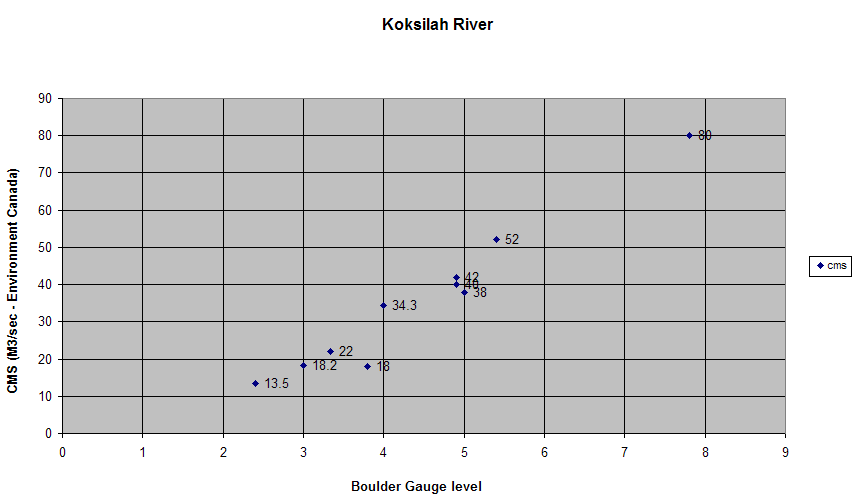
(BB = rough mapping to Burnt Bridge rock gauge)
13-20 cms (BB: 1 - 2) = low 30-40 cms (BB: 3 - 4) = medium 50-60 cms (BB: 5 - 6) = medium high 70 cms (BB: 7) = high 80 cms (BB: 8) = very high |
Boats | kayaks, all canoes |
| Season | Nov - March, best after rain | Character | small volume pool-drop |
| Length | 4 h | ||
| Put-in |
(Distances from start of gravel on Renfrew Rd)
|
||
| Takeout | Either at Burnt Bridge, or at the Clearwater RV and Tenting campsite on Glen Eagles Rd. | ||
| Features |
The run starts fairly quietly, but there are 3 good-sized drops in the last half
(one right above Burnt Bridge, but separated from it by
enough calm water to allow taking out there, if desired).
|
||
| Comments | |||
| Run | Koksilah Canyon | Class | III (IV) |
| Level | lower volumes
Best level is 0.9 - 1.4 m on the Bright Angel gauge. This river is small and flashy, so it can be hard to predict what level you're going to find. |
Boats | kayaks, solo canoes |
| Season | Nov - March | Character | remote canyon, small volume pool-drop |
| Length | 5 h | ||
| Put-in |
Usually at
Kinsol Trestle
, but can be run from Campsite
Approach from Koksilah Rd off Hwy 1; stay left. |
||
| Takeout |
Bright Angel Park bridge
There are no other convenient takeouts along the run, but there are accesses that could be used in an emergency:
|
||
| Features |
|
||